Sections
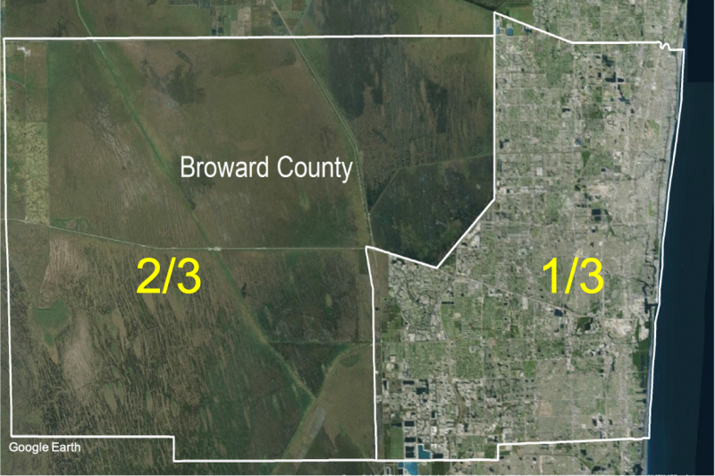
Broward County is located in southeast Florida. It is the seventh-largest county in the state and ranks number two in population. As shown in the figure below, the western two-thirds of Broward County is entirely undeveloped as part of the Everglades Water Conservation area. A protective levee runs north to south in order to hold the water four feet higher in the west portion of the county.
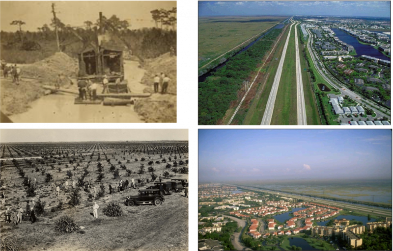
Land development began in the 1920s. Canals, originally constructed for drainage and flood control, allowed for extensive urban development.
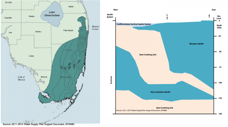
Broward County’s main source of water comes from the Biscayne Aquifer (figure below), one of the most productive aquifers in the world. It provides nearly 1 billion gallons a day on average. The Biscayne Aquifer is an unconfined coastal aquifer, which means it is heavily recharged from the surface and rainfall and is also influenced by the coastal boundary with the Atlantic Ocean. Because it is highly permeable and lies at shallow depths, it is vulnerable and readily susceptible to contamination. Water quality pressures exist from the urban environment and from the ocean.
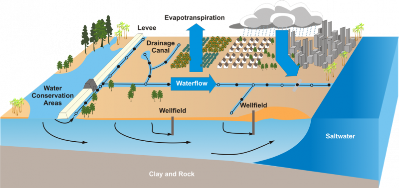
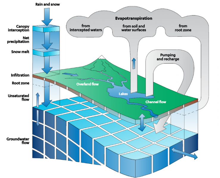
The figure below demonstrates the strong level of integration in Broward’s water system. Biscayne aquifer is very shallow and sits just a few feet below ground in most parts of the county. Canals are an important feature, connecting to groundwater and providing direct recharge, as well as flood protection and control of saltwater intrusion. The wellfields must be maintained in the fresh portion of the system, which is becoming more difficult as sea level rises. Withdrawals and recharge are carefully managed to protect wells from saltwater contamination. We also seek to Maintenance of groundwater elevations, mostly through the canal system operation, is imperative to prevent seepage from the Everglades, since the amount of water we can extract from the Everglades is limited.
Water systems stressors include:
- Human-induced Stresses:
- Urban Development
- Wellfield pumping
- Canal water level management
- Everglades Drainage
- Agricultural Needs
- Lake Okeechobee Regulation Schedules
- Natural Stresses (and Climate Change):
- Sea level rise
- Extreme events
Broward County has many water managers, including twenty-five water providers, fifteen sewer providers, and over twenty control/drainage districts managing stormwater. Coordination among all those actors is essential for the optimization of our water system and managing in a more productive way.
Here is a list of some of the primary water policies driving decision-making in Broward County:
- 1972 – Land and Water Management Act (Areas of CriticalState Concern) and Florida Water Resources Act
- 1985 – Growth Management Act (+ later amendments)
- Water Supply Facility Work Plans
- 2002 – Florida Water Conservation Initiative
- 2007 – Regional Water Availability Rule
- Alternative Water Supply
- 2008 – Ocean Outfall Legislation
- Mandated Beneficial Reuse
- 2011 – Numeric Nutrient Criteria
- Stricter water quality protections
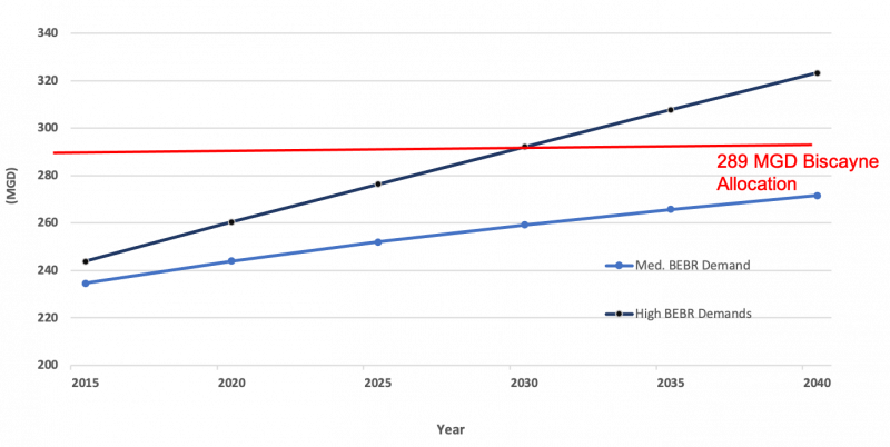
Broward County is planning for tomorrow. Documents such as the task force report from 2010, the recently approved lower east coast plant, and the RCAP 2.0 demonstrate the importance of comprehensive planning and understanding all aspects of water management. There are limitations imposed by the systems. For example, data shows a cap in the allocation of the Biscayne Aquifer, and the higher projections show that the cap may be achieved by 2030 (next figure).
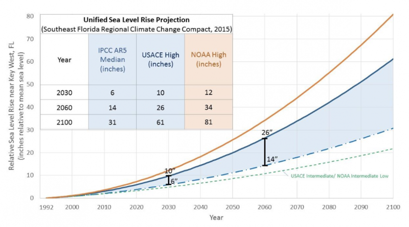
Sea level rise is expected to impact Broward County (figure below). Knowing the range of sea level rise is a useful tool when engaging with stakeholders to determine which projection to plan for.
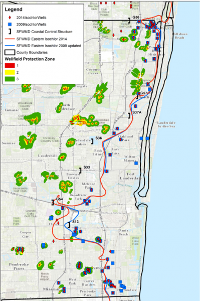
One challenge addressed in the planning documents is saltwater intrusion as seen in the next figure. By 2060, it is anticipated that 16 percent of Broward County’s coastal withdrawal wells will be threatened by saltwater intrusion. Several wells have already shut down due to higher salinity levels. Many of them are being moved towards the west and coordination between utilities is underway to ensure adequate water is available to all parts of the county.
The Broward County Water Resources Plan is an online tool that is updated continuously to provide current information. Some main elements of this plan include a focus on flood management and stormwater management. We are working with a host of actors to develop this plan and to engage and educate the public.
2019 IWRP Report: For the first time, the goals of this report included the importance of evaluating climate impacts and adopting resilience adaptation strategies. “To promote water resources resiliency by evaluating future conditions, including potential climate impacts and adopt strategies to mitigate, adapt, and prevent disruptions to our overall goal of more efficient and effective water management.”
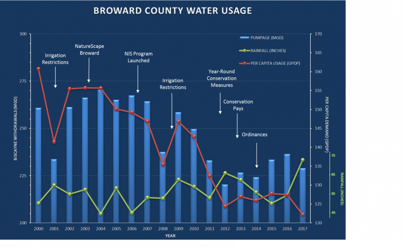
This next graph demonstrates the significant per capita reduction that was driven by a series of water conservation programs in the county. This includes irrigation evaluations, home visits to help optimize indoor and outdoor water use, taller rebates, the Conservation Pays program, and twice-daily irrigation restrictions. Investments in educational and other programs have resulted in reduced per capita water use, a trend planners trust will continue moving forward.
Beyond the Biscayne Aquifer, the next preferred water resource is the Floridan Aquifer seen in the figure below. Floridan has been the next preferred resource, but it is a saltier aquifer with more expensive development costs, and requires a higher level of treatment.
Another strategy is reclaimed water development. A reuse master plan guides investments in the region, as well as a grant program implemented with partner municipalities to advance those reuse projects. Challenges to traditional reclaimed water implementation include:
- Developed urban areas - densely populated urban core with developed infrastructure doesn’t allow space for new infrastructure.
- Current parcel occupation/size limits the reclaimed water demand and cost efficiency.
- There are 25 distinct water providers (and additional wholesale agreements).
- There are 15 distinct wastewater providers (and additional wholesale agreements).
- There are seasonal demand fluctuations.
- Treatment costs/disposal options are unique to Broward.
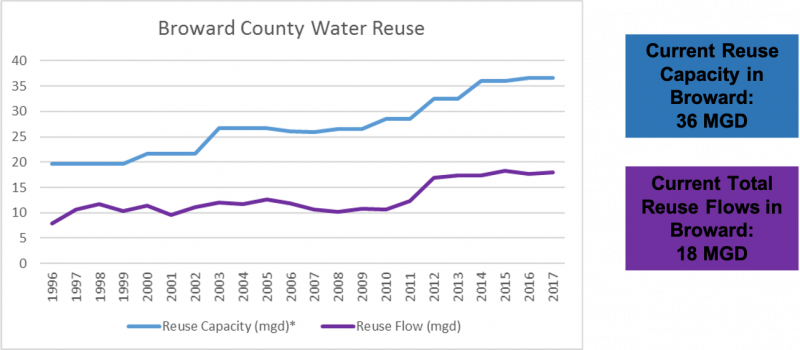
Concerning water reuse capability, the figure below shows the 36 MGD installed capacity for water reuse, but current use utilizes only 18 MGD. The real flow so far represents about 6 percent of county water demand. The goal for the next plan is to increase this to 24 percent by 2040.
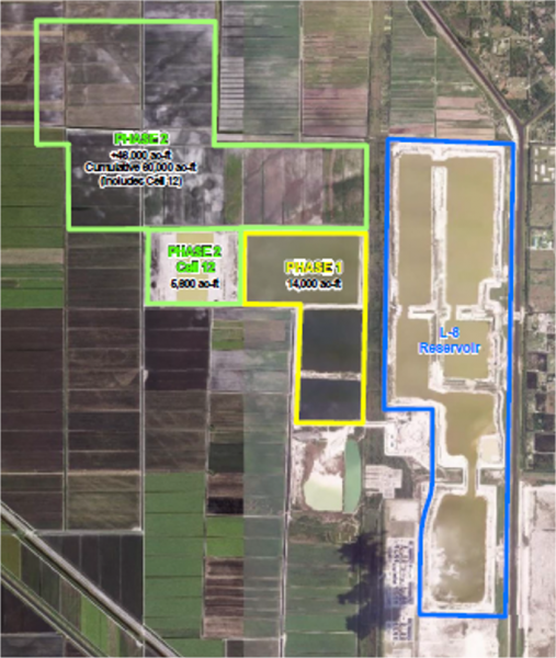
Another significant regional alternative water supply project, shown below, is the C-51 Reservoir, designed as a public-private partnership between Broward, Palm Beach, and Miami-Dad counties, and the South Florida Water Management District. The project goal is to capture excess stormwater, reduce harmful discharge in this basin, and increase storage capacity.
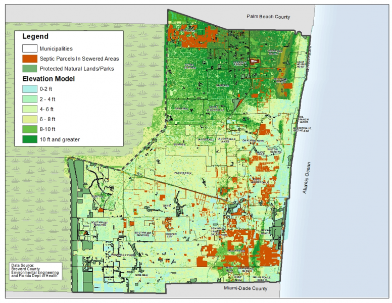
Shifting now to the topic of water quality, the county is now working on an ordinance to address sewer connections in areas where the sewer system is present but the residents are still connected to the sewer operating their septic tanks (see figure below). There are quality issues in Broward County, such as algae bloom in canals, stemming from continued use of compromised home septic systems.
Broward County is also working to advance green infrastructure initiatives. The challenges of limited urban area and limited open spaces increases the difficulty of finding additional places to store water.
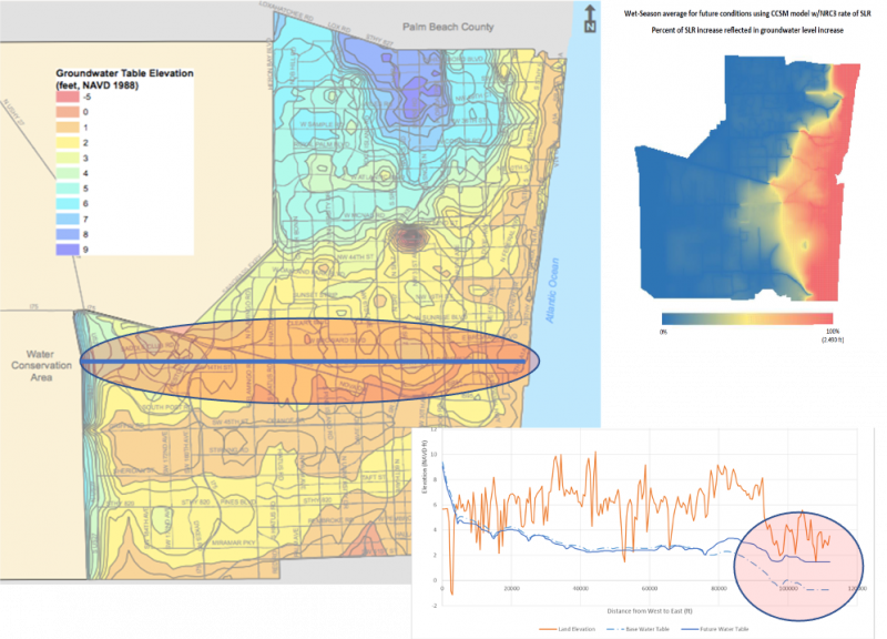
In 2017, Broward County Commissioners approved The Future Conditions map series to use in establishing regulatory criteria based on modern design standards that account for future climate conditions. A sample from the series is shown below.
The Future Average Wet Season Groundwater Elevation Map (upper right corner in the previous figure) depicts groundwater elevation. It sets minimal drainage requirements for major developments and new developments in the county based on data showing rising groundwater levels in the county will cause reduced soil storage.
Future Conditions Flood Elevation graphic (figure below) is currently being developed, and will establish minimal finish for elevations in the county. Every year, the FEMA maps show higher elevations, indicating a need to create a progressive map that anticipates future flood elevations.
- Mapping Future Floodplains
- Increased rainfall due to warming climate
- Year 2060-2069 sea level rise
- Increased runoff due to higher water tables
- Land use changes
- Accomplished through integrated GW/SW modeling
- Will enhance infrastructure resilience
- Regulatory purpose
- Finished floor elevations, streets, sanitary manholes, etc.
Future rainfall is challenging to predict. The future reveals a large range of possibilities. Part of our study is evaluating those data sets.
Develop Rainfall Data Set (options under evaluation)
- Use NOAA Atlas 14 data
- Statistically downscaled localized constructed analogs (LOCA)
- Dynamically downscaled data from COAPS
- Hyperion Group Data
- Probabilistic Approach
Other Considerations
- Future average GW levels from BC MODFLOW models
- Future Land Use
- Future Structure Operations Planned Infrastructure Improvements
- No storm surge (FEMA Coastal Zone A)
- No joint probabilistic distribution analysis
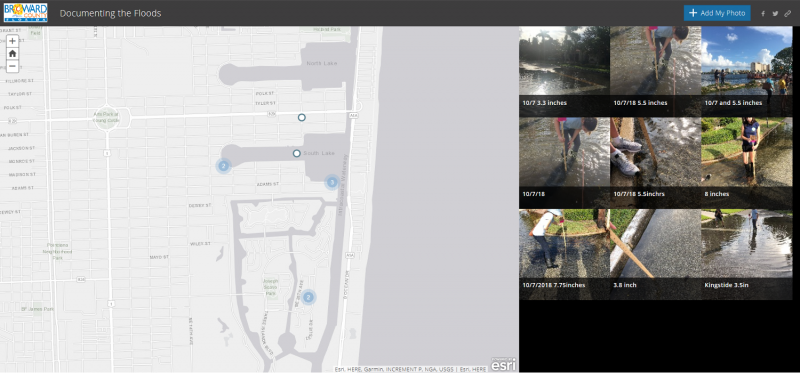
The county is using crowdsourcing tools to identify the distinctions, durations, and currents of floods in the county (next figure).
Also in the works is a utilities dashboard (figure below) that will show water demands and other resilience aspects, as well as how the utilities are dealing with those resilience discussions and aspects in the county. Water resource resilience aspects to be incorporated in this tool include:
- Complex Water Management System – Integration GW and SW
- Reliance on Biscayne Aquifer as main source of water supply (more affordable alternative)
- Future Water Supply Demands and Integration with Flood Protection System
- Alternative Water Supply Options (Reuse, C-51 Reservoir, Floridan)
- Septic Tanks and Water Quality Issues
- Stormwater Green Infrastructure
- Future Conditions –Flood and Droughts (precipitation extremes)
Broward County is working with the Resilience Utilities Coalition, grouping the utilities in South Florida to discuss resilience, academia, and other contributors. The goal is to advance investments and form the capital planning on those needs, as well as to include data analytics, cyber security, climate vulnerability, emergency preparedness, and community involvement in all discussions.
