High metal bridge across a large expanse of water

Infrastructure

Most of the Northwest’s infrastructure was designed for an unchanging climate. As the frequency and/or intensity of flooding, drought, wildfire, and heat waves changes, proactive management of transportation, water, and energy assets can build resilience.

Infrastructure plays a critical role in keeping the Northwest’s economy running smoothly. Damage or failure in any category of infrastructure can disrupt normal operations in single community or result in consequences across the region. Isolated communities are among the most vulnerable to disruptions related to infrastructure.

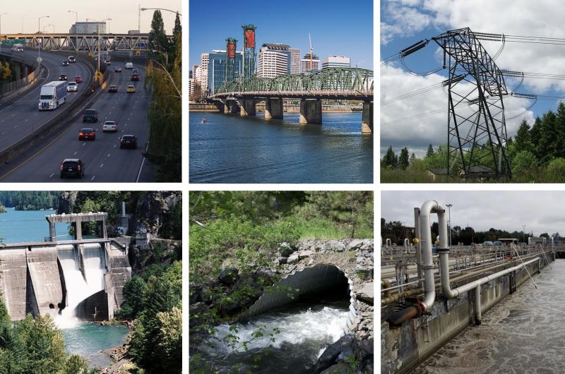
Six frames showing infrastructure listed below

Infrastructure assets keep people, goods, water, and electricity moving across the Northwest. Click the image for credits and sources.

Infrastructure Assets in the Northwest

  • Roads, highways, railways, and shipping ports help move people and goods and support valuable import and export markets.
  • Bridges move traffic over water, transportation infrastructure, and other physical barriers. 
  • Powerlines and substations supply electricity to homes, businesses, schools, and hospitals. 
  • Dams and reservoirs minimize flood risks, generate electricity, and provide water for irrigation and humans. 
  • Groundwater wells are an important water source for agriculture and drinking supplies.
  • Levees and seawalls are built to prevent damage to homes and property along rivers and the coast.
  • Culverts manage water flows to protect roadways from flooding and assist with fish passage, including for migrating salmon.
  • Storm water and wastewater systems help minimize flooding, especially in urban areas, and are critical for maintaining water quality.
Climate-related hazards to regional infrastructure

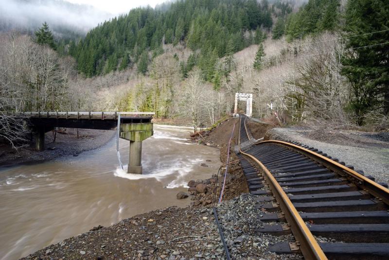
A failed bridge and sagging railroad tracks, undermined by erosion from flooding

Storm-driven flood damage to the Salmonberry Bridge & Port of Tillamook Bay Railroad in Salmonberry, Oregon. December 2007. Photo by Chris Updegrave. Click image for more information.


Flooding, sea level rise, and coastal erosion

Wave crashing on rocks

Sea level rise is slow, but relentless. And permanent on human timescales. Energy from crashing waves constantly chips away at higher levels along the coast.

Along the coast, sea level rise is projected to increase flood risks in low-lying areas. By the end of this century, rising waters could impact significant infrastructure along Northwest coasts, particularly in the low-lying urban areas of the Puget Sound and Portland. Higher sea level will also likely magnify the potential for coastal erosion and infrastructure damage from storm surge and intense wave action.

For example, during the 2015–2016 extreme El Niño winter, several major storms hit northwestern Oregon. Tillamook County experienced a state of emergency that included major highway and road closures due to flooding, failed culverts, landslides, and sinkholes. Disruptions in transportation networks reduced access to food, healthcare, and social services. This event highlighted the need to maintain alternate routes so communities so supplies and services can reach them if they become isolated.

Landslides

Homes and a field along a road that is blocked by two mudslides off a forested hill

Heavy rainfall can lead to slope instabilities and landslides, which occasionally close roadways and railways. An increased risk of landslides is expected across the Northwest, as more mixed rain and melting snow events occur in low- to mid-elevation mountains.

Increases in the amount of precipitation falling in heavy rainfall events (including in atmospheric rivers—"trails" of water vapor that move through the sky, similar to the way a river moves over land) are anticipated to magnify these risks. Some bridges and stretches of highway along the coast are exposed to coastal erosion and landslides.

The Washington State Department of Transportation is implementing a Landslide Mitigation Action Plan to proactively address the climatic and other factors contributing to landslide-based rail closures.

Drought & Wildfires 

Low water and dried sediments below forested hils

Low water levels at Blue River Reservoir in Oregon in the fall of 2014. When compared to larger urban water systems, some of the Northwest's small, typically rural systems are relatively more vulnerable to drought impacts.

Changes in water quality and quantity present challenges for water infrastructure during drought conditions. In 2017, Washington provided relief funding for backup or emergency water supplies for irrigation or human consumption where wells were failing or pumping capacity was inadequate.

Wildfires sometimes result in road and railway closures. They are also associated with reduced water quality in reservoirs and impacts on the energy sector. Fires create negative economic impacts on tourism and regional small businesses, reducing their ability to upgrade or maintain local infrastructure.

Water

Stream flowing over rocks through trees with mountains in background

As temperatures rise, the proportion of cold season precipitation falling as rain rather than snow increases: this raises the risk of springtime flooding. Summer stream temperatures are expected to increase, reducing water quality and habitat for fish.
 

As winter snowpack melts earlier, late spring and summer streamflows are anticipated to decline. Low flow periods are also projected to be longer and more severe. In areas where residents and ecosystems have historically relied on snowmelt for their water, supply may become less reliable.

At the same time, rapidly melting spring snowpack also increases concerns about flooding. The story of water in the Northwest may alternate frequently between too little and too much.

In coastal areas, sea level rise will likely lead to saltwater intrusion into groundwater supplies.

Successes and Challenges

Communities across the Northwest are working to identify strategies that enhance community resilience and emergency response capacity to many types of hazards and potential disruptions. Planners in large urban areas such as Seattle and Portland have been investing in building climate resilience for their systems for more than a decade. Such cities often partner with university researchers to develop tailored climate risk information and adaptation strategies. Across the region however, many smaller cities and rural towns have done less to confront the climate challenges they may face, and the lack of redundancy within infrastructure systems may limit their adaptive capacity.

Water in foreground with a high bridge crossing it

The twin Marion and Center Street bridges in Salem, Oregon are the only river crossings for cars and trucks for many miles, with the exception of a small ferry. 

Some lifeline roadways that serve as the only means to access communities can leave people and assets highly vulnerable. Disruptions to these roadways could cut off communities from supplies and services. The lack of redundancy in transportation networks has also been noted for several of the region’s National Parks, contributing to their vulnerability.

Metal bridge spanning a river

In 2009, Salem's Union Street Railroad Bridge was converted to a pedestrian and bike bridge. The bridge is also engineered to allow emergency vehicle access to supplement the Marion Street and Center Street bridges.

Infrastructure managers are beginning to consolidate planning for the combined risks of sea level rise, flooding, and seismic hazards. Adaptation strategies that address more than one sector, or are coupled with social and environmental co-benefits, are among the most efficient strategies to increase resilience. Additionally, the use of “green” or hybrid “green and gray” infrastructure that utilizes nature-based solutions is emerging as a potential adaptation option. 

This text is excerpted and abridged from the report Climate Change Impacts in the United States: The Fourth National Climate Assessment (Chapter 24: Northwest).

Banner Image Credit
Photo of Astoria - Megler Bridge in Oregon by Alienturnedhuman at English Wikipedia, CC BY 3.0 <https://creativecommons.org/licenses/by/3.0>, via Wikimedia Commons. https://commons.wikimedia.org/wiki/File:Astoria%E2%80%93Megler_Bridge.jpeg
Last modified
10 April 2022 - 5:30pm