Online Training for Water Utilities | WUCA
This training course for water utility managers and consultants, developed by the Water Utility Climate Alliance (WUCA), covers methods for including climate science in water supply planning processes.

Adaptation Decision-Making at Metropolitan Water District of South California

The video is a recorded presentation delivered in May 2019 as part of a two-day technical training course held by the Water Utility Climate Alliance (WUCA) in Tampa, Florida. The course was attended by drinking water and wastewater utility managers and consultants from across the United States.

Watch the whole video, or browse the content by section below. Click any section title to jump directly to that content in the video. All slide images were provided by the presenter.

Instructor
Brandon Goshi
26:00 minutes

Introduction

The Metropolitan Water District (MWD) of Southern California is a water wholesaler for six counties. Hear Brandon Goshi, Manager of Water Policy and Strategy for the MWD describe how they incorporated uncertainty planning, robust decision-making processes, and an integrated resources plan (IRP) to develop and test various future scenarios. The outcome is an adaptive IRP providing a robust pathway forward, one that takes into consideration the vulnerability of the water sources to future uncertainties.

Key Points

  • The analysis approach was developed using RAND (NEED TO KNOW WHAT THIS STANDS FOR).
  • This supports an adaptive decision-making approach.
  • RDM incorporates data, modeling, and analytics.
  • RDM evaluates systems against a wide range of uncertain future conditions.
  • RDM identifies factors leading to when and why scenarios fail.
  • The approach informs signposts and monitoring criteria for adaptive management and practicable implementation.
About the Metropolitan Water District of Southern California
0:02:06
0:06:55
(4.5 minutes)

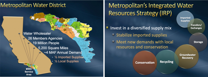
The Metropolitan Water District of Southern California (MWD) is a water wholesaler, not a retailer. The MWD covers six counties in southern California, spanning over 5200 square miles, and imports water into the southern California area because southern California does not have enough of its own locally-supplied water for the needs of the people. (See figures below.)

Metropolitan water district overview

Map of the Metropolitan Water District and its organization.

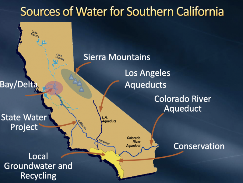
The MWD is represented by the yellow area in the figure below. Where does the water come from? The portfolio includes local water with small surface diversions, recycling, water from the Sierra Mountains and the Colorado River, and local groundwater. The latter makes up a significant part of the overall portfolio, approximately 1.2 million acre-feet (1 acre-foot is about 326,000 gallons.)

Sources of water for southern California

Sources of water for southern California.

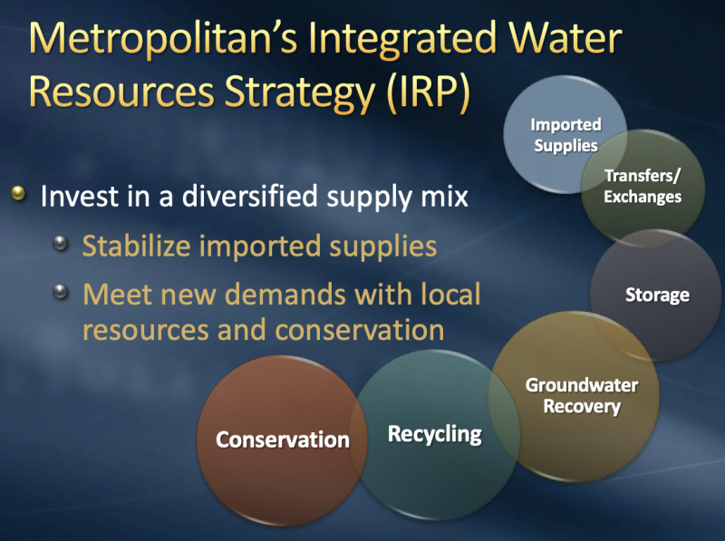
The MWD developed an Integrated Water Resources Strategy (or Integrated Resources Plan, IRP) in 1996 and included stakeholder involvement in the work. A major outcome of the IRP was recognizing the MWD could invest in a diversified supply mix (next figure). This mix could include imported water, buying water on a voluntary basis, transfers, or exchanges from other entities. It could involve building either surface or groundwater storage, manage groundwater recovery, or even to clean up contaminated water and use some of that supply, recycling, or conservation.

MWD's integrated water resources strategy

MWD's options for a diversified water supply mix. 

Review of Uncertainty
0:06:56
0:10:03
(3 minutes)

"There are known knowns; there are things we know we know. We also know there are known unknowns; that is to say we know there are some things we do not know. But there are also unknown unknowns – the ones we don't know we don't know."

~Donald Rumsfeld

Some “known knowns” for MWD include:

  • Official demographic projections can be determined on economic growth, population size, and other variables.
  • Project parameters of the supplies we have are relatively known knowns. We know when they will go online and their capacity and yields.
  • We can compare historical weather outcomes as a possible sample of current weather patterns.
  • There are others.

Some “known unknowns” for MWD include:

  • Existing projects may experience loss and/or yield reductions due to regulatory, internal, or environmental reasons.
  • There may be changes in project parameters.
  • There may be regulatory changes in the way that water quality constituents may be.
  • There may be shifts in demographics and growth away from whatever the official parameters may have been.
  • There may be economic boom and bust cycles away from the original projection.
  • There are known unknowns around climate change and what it may look like in terms of impacts.

Some “unknown unknowns” for MWD:

  • Noone knows what these are, because that’s the whole point of unknown unknowns!
Overview of the Integrated Resources Plan (IRP) Robust Decision Making Process
0:10:04
0:16:24
(6 minutes)

It is important to be sure to do this work in a way that is understandable and accessible to all involved audiences, and make sure what you do is practicable to ensure that it is implementable.

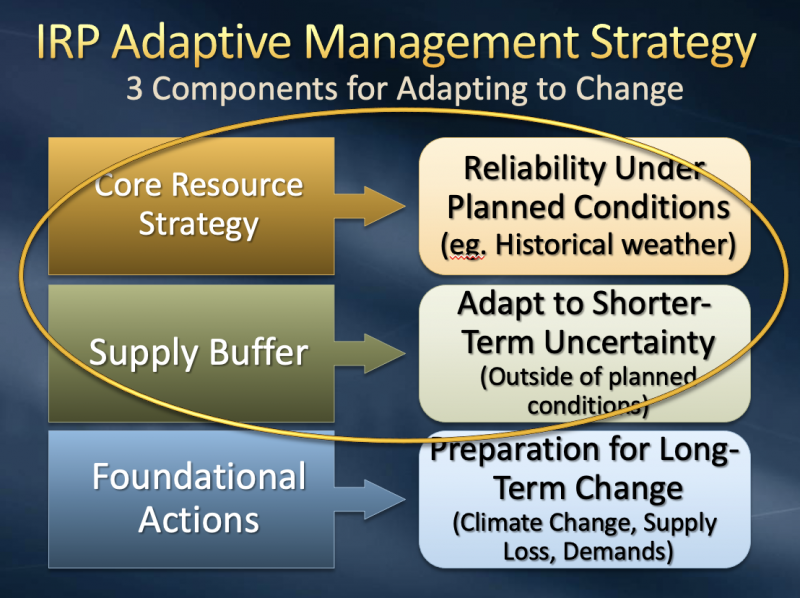
In 2010 the MWD adopted an Integrated Resources Plan (IRP), in conjunction with an adaptive management component, to incorporate the practical or practicable aspects of what could come out of an RDM analysis. The figure below outlines the three categories of change in the IRP. The third, Foundation Actions, includes those potential resources to invest in to prepare for long-term change, but many of them aren’t quite ready for primetime, such as large-scale ocean desalination.

The 2010 MWD IRP strategy

The 2010 MWD IRP strategy.

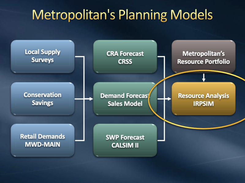
MWD planning models

The Metropolitan Water District's planning models.

To explore future needs, MWD uses a resource calculator called IRPSIM. Under varying weather conditions over time, program in the operational rules and resources and it can provide answers regarding if there will be a shortage or surplus, how much storage was used, and other information. IRPSIM uses 30 supply sources and programs, 10 demand categories, 20 storage and transfer programs, 1000+ supporting variables, and 24 operational stages, which are rules for how the simulation works. IRPSIM gives us 50 years of supply and demand simulation and over 83 hydrologic traces, or outcomes in total.

In summary, IRPSIM runs on: 50 Years x 83 Traces x 1000 Variables x 24 Stages ≈ 100 Million Calculations

The simulation takes about 8 seconds per run.

Incorporating Uncertainty in an Existing Model Framework
0:16:25
0:19:13
(3 minutes)

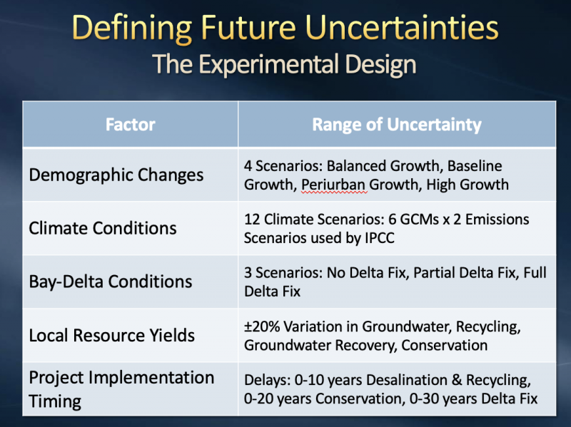
To do RDM, or intensive scenario planning, we use the following inputs and framework. The IRPSIM resource uses a process called scenario discovery and is illustrated in the following two figures.

Incorporating uncertainty model

Incorporating uncertainty model.

Defining future uncertainties

Defining future uncertainties.

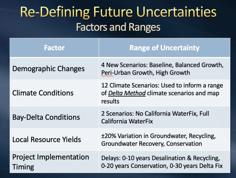
The RDM Analytical Approach analyzed over 6,900 combinations of uncertainty. We used “scenario discovery” to identify where the IRP Resource Mix failed with net balance and total storage. Using statistical methods, we determined common areas of vulnerability.

The analytical steps include:

  • Configuring IRPSIM with “Core Resources Strategy and Buffer” of the IRP
  • Evaluating “Core Resources Strategy and Buffer” with Experimental Design
  • Identifying when the IRP fails based on specified markers/thresholds
  • Identifying factors that led to failure
  • Developing “signposts” for monitoring data associated with uncertainty factors
Key Findings from RDM
0:19:14
0:25:50
(6.5 minutes)

Summary of RDM Conclusions:

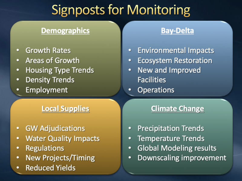
  • The IRP approach is vulnerable when two or more uncertainties turn out unfavorably (next figure).
    • Example: High inland growth combined with an increasingly hot/dry climate
  • Key uncertainties to “signpost” and monitor include future delta conditions, demographic trends, groundwater yields, and climate conditions.
Signposts for monitoring

Signposts for monitoring.

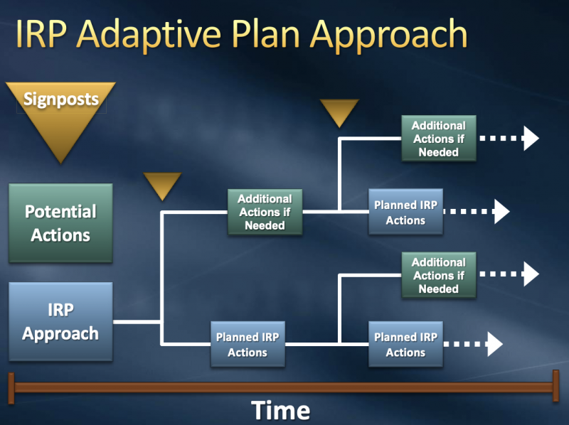
Over time, we’re going to be looking at the different signposts that define potential actions that may be developed through the foundational actions mentioned above, and the IRP basic approach (next figure). This is basically saying that over time I will implement the IRP actions. At certain points in time, I can look at the signposts which have been shortened by the foundational actions aspect of the adaptive management plan. If signposts indicate I should take a different track than what the basic IRP plan is, I can add those additional actions or make modifications.

IRP adaptive plan approach

IRP adaptive plan approach.

Recently, we went through a new rendition, seen in the figure below. Here, you’ll see the Delta Method was used instead of the 12 scenarios for climate conditions. This is an example of taking action on vulnerability, rather than waiting for a new model. This created a new way for us to look at climate information.
Re-defining future uncertainties

Re-defining future uncertainties.


Online Training for Water Utilities | WUCA

Chapter 1: Introduction
Unpredictable rainfall, stronger storms, and changes in historic weather patterns are just some of the observed effects of climate change. You can’t afford to be unprepared for emerging conditions and, on the other hand, you can’t be prepared for everything—and it’s not financially feasible to prepare for the worst-case scenario. Developing a plan to assess the vulnerability of your utility is essential for building resilience and ensuring you, and your customers, are prepared for a changing future. This short module provides an overview to get you started on the right foot.
Instructor
Laurna Kaatz
4 Sections
12:10 Minutes
Developing a plan to assess the vulnerability of your utility is essential for building resilience and ensuring that you, and your customers, are prepared for a changing future. This module provides an overview to get you started on the right foot.
Chapter 2: Understand
You are ready to begin assessing the vulnerability of your water utility. The first steps involve an understanding of climate science, a look at projected future climate scenarios, and an overview of how climate data is collected and applied to your specific project. With these tools in your toolkit, you can move on, with confidence, to planning your assessment.
Instructor
Joel Smith
9 Sections
50:53 Minutes
This course module reviews observed and projected climate change as well as many sources of uncertainty, particularly focusing on the southeastern United States.
Instructor
Julie Vano, Ph.D
8 Sections
27:26 minutes
Global climate models represent climate data at a high resolution. Downscaling produces accurate global climate data at a resolution useful on a local scale.
Chapter 3: Plan
How do we make decisions in light of uncertainties, especially when those decisions will last a long time? The next two lessons will show you how to move into the future with confidence.
Instructor
Rob Lempert, PhD; & Michelle Miro, PhD
7 Sections
47:00 minutes
This course module reviews observed and projected climate change as well as many sources of uncertainty, particularly focusing on the southeastern United States.
Chapter 4: Implement
Instructor
Wendy Graham, Ph.D.
6 Sections
27:30
Once you plan the work, it's time to work the plan! The two lessons in this chapter show real-life examples of implementation in southwest Florida.
Instructor
Chris Martinez, Ph.D, and Kevin Morris
8 Sections
16:20
This course module reviews observed and projected climate change as well as many sources of uncertainty, particularly focusing on the southeastern United States.
Chapter 5: Case Studies
Instructor
Tirusew Asefa, Tampa Bay Water
7 Sections
20:00 minutes
This course module reviews observed and projected climate change as well as many sources of uncertainty, particularly focusing on the southeastern United States.
Instructor
Ana Carolina Coelho Maran, Ph.D., P.E.
5 Sections
24:30 minutes
This course module reviews observed and projected climate change as well as many sources of uncertainty, particularly focusing on the southeastern United States.
Instructor
Brandon Goshi
6 Sections
26:00 minutes
This course module reviews observed and projected climate change as well as many sources of uncertainty, particularly focusing on the southeastern United States.