Online Training for Water Utilities | WUCA
This training course for water utility managers and consultants, developed by the Water Utility Climate Alliance (WUCA), covers methods for including climate science in water supply planning processes.

Translating Climate Science into Hydrology

The video is a recorded presentation delivered in May 2019 as part of a two-day technical training course held by the Water Utility Climate Alliance (WUCA) in Tampa, Florida. The course was attended by drinking water and wastewater utility managers and consultants from across the United States.

Watch the whole video, or browse the content by section below. Click any section title to jump directly to that content in the video. All slide images were provided by the presenter.

Instructor
Julie Vano, Ph.D
27:26 minutes

About This Lesson

Why should we downscale? Raw outputs from global climate models (GCMs) do not represent precipitation, temperature, clouds, snow, or other meteorological phenomenon at a resolution that people desire or can use for planning. Downscaling can be used to translate global climate model output to relevant local scales. To better understand how future climate could affect water supply and water use scenarios, Tampa Bay Water dug deep into the data to find an effective way to generate future changes using GCM projections while also accouting for important local conditions. And to do that, they had to downscale.

Key Points

  • Downscaling and hydrology modeling provide local-scale insights into possibilities projected by global climate models.

  • There is a continuum of downscaling approaches that spans tradeoffs between computational efficiency and methodological complexity.

  • Some change signals are more certain than others.

  • Some uncertainty is unavoidable.

Why Do We Need to Downscale?
0:00:05
0:03:04
(3 minutes)

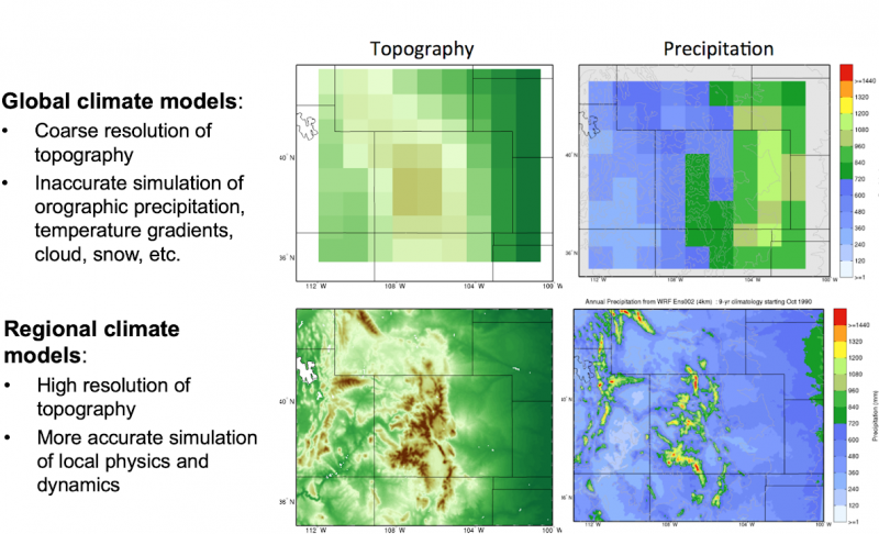
Downscaling provides insights into climate impacts at more local scales. Many impact models and modelers require  information (e.g., precipitation, temperature) at finer-scale than what is provided by GCM output. Downscaling helps capture local topography and associated temperature and precipitation patterns and can help to correct for known biases in the GCMs.

The graphic below shows the benefits of downscaling.  In the series of maps centered on the state of Colorado, the top panels show topography and precipitation at the resolution of global climate models and the bottom panels at the resolution of regional climate models.  

Examples of Global and Regional Climate Models

Downscaling brings global data to a regional and local scale. Top panels show topography and precipitation at the resolution of global climate models, bottom panels are at the resolution of regional climate models.

Types of Downscaling
0:03:05
0:11:33
(9 minutes)

Downscaling is typically thought of as two different types: dynamical and statistical. There are, however, many approaches to downscaling that lie along a continuum of increasing physical complexity; some are dynamical, some are statistical, and increasingly new techniques blend dynamical and statistical downscaling.

Dynamical downscaling uses high-resolution regional climate models to simulate local dynamics over the area of interest. The global model output is applied along the model boundaries and initial conditions and the physics (e.g., energy and momentum) are then simulated. Dynamical downscaling is computationally intensive and usually requires supercomputers. This limits the number of model realizations (e.g., different global climate models, different emission scenarios) available.

Statistical downscaling statistically relates global climate model projections to fine-resolution historical observations. The (stationary) statistical relationships are then applied to future global model output. Statistical downscaling output is usually only available for a subset of variables (temperature, precipitation) which have observations adequate to develop the relationships. Statistical downscaling is computationally inexpensive, and doesn’t require supercomputers. This results in more model realizations being available.

Climate Attribution Studies
0:11:34
0:13:00
(2 minutes)

Scientists also use these same models to understand how climate change has influenced a particular weather event in the past. Climate attribution studies evaluate  the extent to which an event may have been influenced by global warming – e.g., because of warming, how much more likely is a the possibility of a storm with Hurricane Harvey’s precipitation intensity.

What to Consider When Choosing a Downscaling Technique
0:13:02
0:14:05
(1 minute)

When selecting a downscaling technique for your project, consider the following factors while making your decision:

  • How large is the area of interest?
  • Where is the area of interest?
  • What is the impact of interest?
  • When in the future?
  • Does the sequencing of events matter?
  • What type of climate change uncertainty is important?
  • What information is available?
Importance of Hydrology Models
0:14:06
0:20:51
(6 minutes)

Hydrology models represent energy and water fluxes in watersheds. Often, measurements are available for precipitation, temperature, and other atmospheric values in some places, but not others. Hydrology models help fill in the blanks, offering insight into processes such as streamflow, water demand from vegetation, and water temperature.


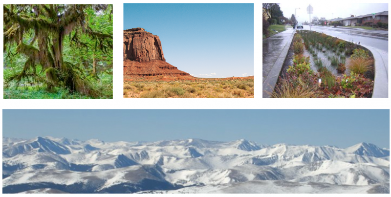
Natural Landscapes Collage

Hydrology models are built to represent many landscapes.


Since models are built to represent many different landscapes, processes, and spatial configurations, they may miss key elements, depending on where and how the model was developed. 

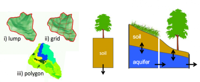
Because they are designed to address specific questions, models can vary in spatial structure, how they are connected, and in model parameters.  (See the images below.)

Types of Hydrology Models

Model spatial structures.

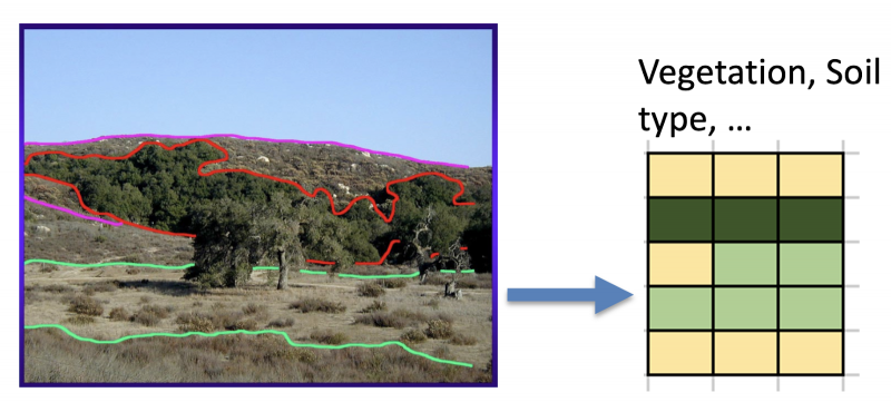
Hydrology Model Parameters

Parameters are also a factor in designing a hydrology model. 

Uncertainties
0:20:52
0:22:23
(2 minutes)

There are uncertainties throughout the modeling chain that include downscaling and hydrology models. Scientists are looking at ways to explore and reveal those uncertainties more effectively. Models can be used to capture a range of results (referred to as uncertainties) in human activities, physical processes, and natural variability.

Conclusion
0:23:00
0:25:27
(3 minutes)

Be aware of the many ways to evaluate future change, but don’t treat all future projections or methods equally. Consider what best fits the question you want answered. 

  • Models and methods should be matched with appropriate questions. 

  • Some questions focus on specific spatial scales and time domains. 

  • Some questions cannot be answered definitively with current knowledge. 

  • Higher resolution doesn’t always mean higher accuracy. 

  • No model is perfect.

Online Training for Water Utilities | WUCA

Chapter 1: Introduction
Unpredictable rainfall, stronger storms, and changes in historic weather patterns are just some of the observed effects of climate change. You can’t afford to be unprepared for emerging conditions and, on the other hand, you can’t be prepared for everything—and it’s not financially feasible to prepare for the worst-case scenario. Developing a plan to assess the vulnerability of your utility is essential for building resilience and ensuring you, and your customers, are prepared for a changing future. This short module provides an overview to get you started on the right foot.
Instructor
Laurna Kaatz
4 Sections
12:10 Minutes
Developing a plan to assess the vulnerability of your utility is essential for building resilience and ensuring that you, and your customers, are prepared for a changing future. This module provides an overview to get you started on the right foot.
Chapter 2: Understand
You are ready to begin assessing the vulnerability of your water utility. The first steps involve an understanding of climate science, a look at projected future climate scenarios, and an overview of how climate data is collected and applied to your specific project. With these tools in your toolkit, you can move on, with confidence, to planning your assessment.
Instructor
Joel Smith
9 Sections
50:53 Minutes
This course module reviews observed and projected climate change as well as many sources of uncertainty, particularly focusing on the southeastern United States.
Instructor
Julie Vano, Ph.D
8 Sections
27:26 minutes
Global climate models represent climate data at a high resolution. Downscaling produces accurate global climate data at a resolution useful on a local scale.
Chapter 3: Plan
How do we make decisions in light of uncertainties, especially when those decisions will last a long time? The next two lessons will show you how to move into the future with confidence.
Instructor
Rob Lempert, PhD; & Michelle Miro, PhD
7 Sections
47:00 minutes
This course module reviews observed and projected climate change as well as many sources of uncertainty, particularly focusing on the southeastern United States.
Chapter 4: Implement
Instructor
Wendy Graham, Ph.D.
6 Sections
27:30
Once you plan the work, it's time to work the plan! The two lessons in this chapter show real-life examples of implementation in southwest Florida.
Instructor
Chris Martinez, Ph.D, and Kevin Morris
8 Sections
16:20
This course module reviews observed and projected climate change as well as many sources of uncertainty, particularly focusing on the southeastern United States.
Chapter 5: Case Studies
Instructor
Tirusew Asefa, Tampa Bay Water
7 Sections
20:00 minutes
This course module reviews observed and projected climate change as well as many sources of uncertainty, particularly focusing on the southeastern United States.
Instructor
Ana Carolina Coelho Maran, Ph.D., P.E.
5 Sections
24:30 minutes
This course module reviews observed and projected climate change as well as many sources of uncertainty, particularly focusing on the southeastern United States.
Instructor
Brandon Goshi
6 Sections
26:00 minutes
This course module reviews observed and projected climate change as well as many sources of uncertainty, particularly focusing on the southeastern United States.