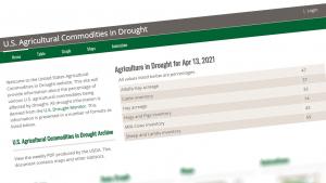
Tools are available to help you manage your climate-related risks and opportunities, and to help guide you in building resilience to extreme events. Browse the list below, or filter by topic and/or tool functionality in the boxes above. To expand your results, click the Clear Filters link.

Screen capture from the Guide
Natural resources planning activities are constantly changing to accommodate new challenges, and it is becoming increasingly important that conservation and land management activities intentionally consider a changing and uncertain climate. This Quick Guide to Adaptation Planning for Natural Resources Professionals gives you a starting point to help you design and implement adaptation actions in your work, with a focus on the project level.  This guide draws on the five-step Adaptation Workbook process desi
Circular diagram showing past and present environmental conditions in Interior Alaska. Source: Community Partnerships for Self-Reliance program
corn field on a clear sunny day
Screen capture from the Adaptation Tool Kit
Close up of cedar branches
Screen capture from the AdaptMap tool
Screen capture from the database website
Screen capture from Beach-fx
Screen capture from Being Prepared for Climate Change
Screenshot from BenMAP-CE
Screenshot from the Bioenergy Knowledge Discovery Framework
screenshot of tool
Screen capture from the BRACE website
Screen capture from the CAKE website
Boats
High Falls, Baptism River, Superior National Forest, Minnesota
Screen capture from Climate Change Resilience Roadmap
Screen capture from the CCRF website
Screen capture from the CREAT website
Screen capture from the Climate-Smart Conservation guide
Screen capture from Coastal Community Resilience Planning Guide
Coastal Resilience Infographic
Screen capture from Coastal Restoration Toolkit
Screen capture from COMET-Farm
Screen capture from the guide's cover
Screen capture of the Convergence website
Screen capture from the CRWU website
Screen capture from a Data Basin map
Cover of the Tribal Climate Adaptation Menu
Screen capture from the DWMAPS tool
Storm clouds loom along the coast of Atlantic City.
screenshot of site
Screen capture from the Flood Resilience Guide
A screenshot of the ecosystem service mapper

Pages