Stressors and impacts
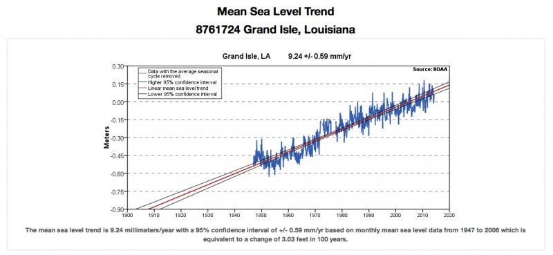
At Grand Isle, Louisiana, rising seas and sinking land add up to one of the highest rates of relative sea level rise in the world. As global sea level goes up and regional geologic processes cause the ground to go down, Gulf waters claim hundreds of acres of land per year. As a result, inland cities are increasingly vulnerable to flooding from tropical storms and hurricanes. Lying directly south of the densely populated city of New Orleans, Grand Isle represents Louisiana's first line of defense from coastal flooding.
Improving on nature
To protect the increasingly exposed land, homes, and businesses of the Gulf Coast, residents of Louisiana have undertaken numerous coastal restoration projects. From neighborhood-scale efforts to plant vegetation along dunes, to sponsored programs that build oyster reefs, to engineering projects completed by state and federal agencies, individuals and communities are taking action to preserve and enhance their coastal environment.
An example of one of the engineered solutions is a series of breakwaters installed just offshore by the U.S. Army Corps of Engineers. These long, low walls absorb the impact of strong waves, reducing their erosive power before they hit the beach. Engineers also built two parallel levees along Grand Isle’s beach. The levees were constructed to resemble natural dunes, and they are covered with vegetation to help them hold their sand in place. The presence of the levees protects Grand Isle from frequent flooding, and helps buffer the cities behind it from the full brunt of Gulf storms.
Adapting to sea level rise and subsidence
Grand Isle illustrates one example of a region adapting to sea level rise. Even as residents and businesses recognize the continual rise of ocean waters and make long-term plans for dealing with their disappearing land, engineered structures that mimic natural systems can help extend the life of Louisiana’s shoreline as it exists today.


