Unique location, unique problems
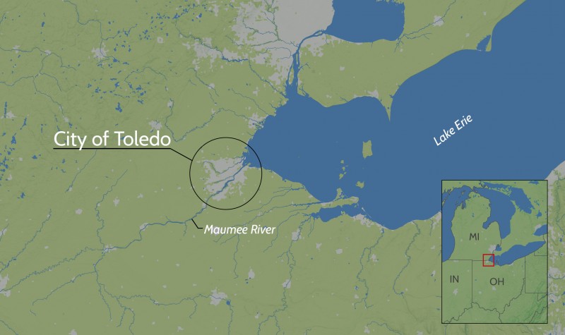
The city of Toledo, Ohio, was built on a low-lying area formerly known as the Great Black Swamp. Situated in the southwestern crook of Lake Erie, the city spans both sides of the Maumee River. Numerous creeks, tributaries, and drainage ditches flow to Lake Erie through the city and surrounding area. The city's relatively low elevation and its proximity to so much water make it highly susceptible to flooding.
Residents of Toledo are also seeing changes in weather patterns. Patekka Pope Bannister, Chief of Water Resources for the City of Toledo, explained in 2014, “Toledo has experienced noticeable changes in weather patterns, specifically extreme rain events that produce flooding issues. These events are responsible for basement and street flooding, shifting foundations, business destruction and disruption, property loss, and millions of dollars in damage.”
While major flooding events receive the most attention, areas that experience chronic flooding from short and intense rains have the same negative impacts. Just an inch of rain over a couple of hours can result in minor flooding in parts of Toledo.
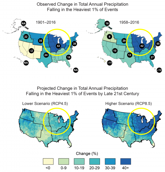
Recently, the city has experienced more frequent and intense rains: annual precipitation rates have risen by more than 40 percent in some areas. Much of the increase is driven by intensification of heavy rainfalls. And the frequency of more intense rains is likely to rise, according to the National Climate Assessment.
Chronic stormwater flooding
Flooding happens when precipitation accumulates faster than an environment can integrate it. The environment naturally integrates water as it is absorbed into the soil, evaporated by the sun, transpired by plants, stored in lakes, or conveyed by streams. Natural resources such as trees, native grasses, and wetlands soak up water. Floodplains absorb flood flows, slowing water flow and allowing soil nourishment.
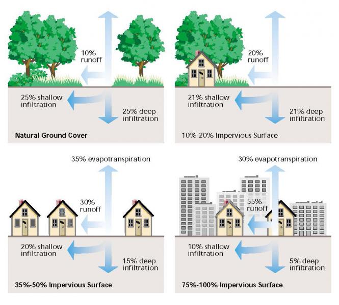
In an urban setting, many of these natural elements are replaced with infrastructure such as parking lots, pavement, buildings, and other impermeable surfaces. These urban features reduce evapotranspiration and prevent precipitation from soaking into the soil and recharging groundwater, leading to increased runoff. The effects are exacerbated when these structures are built within or near floodplains, displacing natural flood storage capacity. Consequently, flooding levels increase and low-lying areas downstream of the building become more flood-prone. Such is the case for Toledo.
Chronic stormwater flooding in urban areas is a multi-scale issue: it can result in standing water where insects breed, basement flooding, property damage, poor water quality, and overloaded stormwater sites that risk community health and safety, and place strains on city budgets. Runoff, particularly agricultural runoff, also oftentimes leads to harmful algal blooms in Lake Erie and other local waterbodies.
Exploring nature-based strategies for adaptation
City staff in Toledo began exploring the use of nature-based strategies to help address their recurrent flooding issues. They started by learning about the concept of green infrastructure, then moved to small demonstration projects. The third step was, as Pope Bannister describes it, "putting large-scale projects in the ground near high-profile areas. This type of project allowed us to look at green infrastructure construction, operation, and maintenance." They also provided an excellent demonstration site to promote local buy-in.
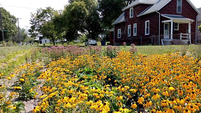
Green infrastructure (GI) is a set of stormwater management techniques and practices that mimic natural hydrologic functions. Commonly, GI incorporates landscape features to store or treat excess runoff. GI can include site-specific management practices such as rain gardens, as well as watershed-scale strategies such as land preservation. The restoration of wetlands and floodplains enhances the land's ability to store water and reduce runoff. In places where urban infrastructure already exists, cities can incorporate or "retrofit" GI during infrastructure replacement and capital improvement projects. GI is gaining widespread support as a credible approach that communities can use to manage stormwater sustainably.
Eventually, Toledo's work in investigating and implementing GI projects led to a collaboration with NOAA's Office for Coastal Management. The combined group worked together to explore what Pope Bannister described as a "city-wide, watershed-based, long-term green infrastructure plan."
Is green infrastructure worth what it costs?
"We received funding from the Great Lakes Restoration Initiative to do a two-year project to work with [Toledo] to help understand their flooding issues and then to see if green infrastructure could be an economically viable solution to help prevent and...deter some of the flooding that [they] were having," explained Lori Cary-Kothera, Operations Manager with NOAA's Office for Coastal Management, in 2014. The Great Lakes Restoration Initiative is a program administered by the U.S. Environmental Protection Agency (EPA).
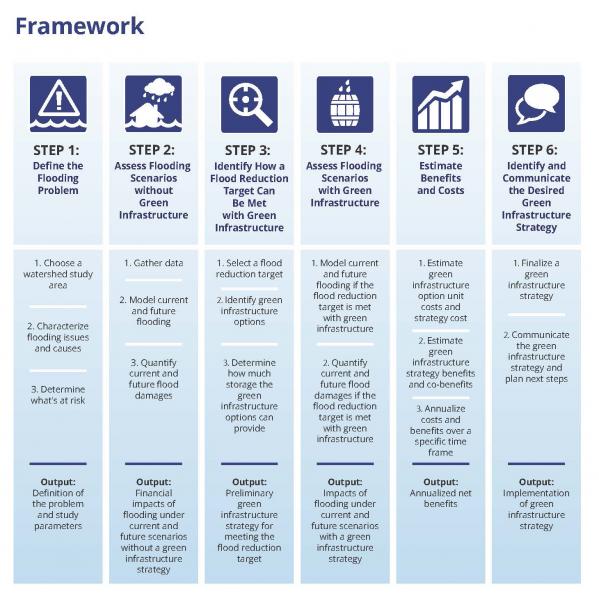
The project team—which grew to include representatives from the City of Toledo's Division of Environmental Services, NOAA's Office for Coastal Management, the U.S. Army Corps of Engineers, the Association of State Floodplain Managers, research and engineering firms, and other state and local partners—undertook an economic assessment of green infrastructure for Toledo's Silver Creek watershed, a 15-square-mile area in the northwest part of the city. The team used a framework to compile information about current and future flooding and to help them better plan for projects that could reduce flood impacts. The framework they used for the assessment was later formalized by NOAA project participants in the 2016 publication A Guide for Assessing Green Infrastructure Costs and Benefits for Flood Reduction.
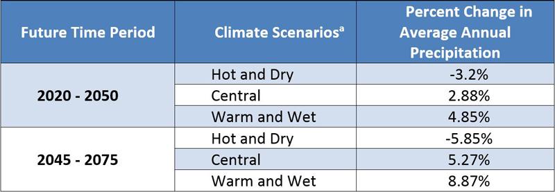
First, the group needed to understand current precipitation rates and land use options. Second, they would look at future projections. Data and land use characteristics (both current and historic) were retrieved from NOAA's CCAP Land Cover Data. For future scenarios, they worked with EPA's Climate Resilience Evaluation & Awareness Tool (CREAT) and extrapolated future precipitation results. The tool projected changes in average annual precipitation, varying from a 3.2 percent decrease to an 8.9 percent increase in Toledo (see table). The projections are a range of values from three model projections (hot and dry, central, and warm and wet); the warm/wet model projection provides a worst-case scenario with the greatest increase in precipitation throughout the year. This was the model used for the Toledo economic assessment.
To see how water would move across and within the landscape, the project team partnered with the U.S. Army Corps of Engineers for hydrology modeling. To identify where flooding was likely to occur and determine its impacts within the watershed, they partnered with the Association of State Floodplain Managers to run a FEMA HAZUS model to better understand impacts to buildings. Only then were they able to start looking at flood reduction scenarios by incorporating green infrastructure.
Using a 100-year flood event for analysis, the team worked through an iterative process to determine a goal: to reduce peak flow by 10 percent. They then calculated how much green infrastructure storage was needed to reach that goal. Their analysis indicated that they needed 30 acre-feet of storage for current conditions and 32 acre-feet for projected future conditions. (One acre-foot of storage is the amount of water it takes to cover one acre of land with one foot of water. The volume is approximately 327,000 gallons of water.)
Next, the team tackled the complicated process of figuring out how much storage each identified green infrastructure option would yield. The team also wondered if they could find room for that volume of storage within the highly urbanized watershed, which is about 90 percent impervious pavement. The team undertook site visits, conducted interviews, and "ground-truthed" possible options to determine what was actually possible. Based on their findings, they narrowed the list of possible green infrastructure options down to five: bioretention/bioswales along unimproved roads; blue roofs (building materials that provide temporary water storage and gradual release of stored water) and permeable pavement along unimproved roads; permeable pavement for unimproved roadways and sidewalks; underground storage; and parcel buy-outs for on-site detention.
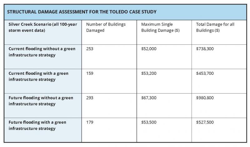
But the team still wondered if they would actually able to reduce potential flood damages sufficiently using green infrastructure. They reran their flood model, including both current and projected future precipitation and land use with the implementation of identified green infrastructure. Results indicated that the GI plan could reduce the costs of flood damages by a substantial amount. Under current conditions, estimated damages of $740,000 could be reduced to $450,000 using green infrastructure. For future flood scenarios, damages could be reduced from approximately $900,000 to $500,000.
Calculating return on investment
Of course, cost must be considered when deciding which green infrastructure practices should be implemented. The project team performed a literature review of available green infrastructure costs nationwide, looking at both capital outlay and operations and maintenance costs per square foot of surface area and per cubic foot of water storage.
Reductions in damages associated with flood mitigation strategies were represented as benefits. While the economic benefits would likely be widespread, data limitations meant the team could only quantify damages to buidings, the largest benefit of flood mitigation in Toledo. Other potential benefits—such as improved water quality, increased habitat, increased green space, reduced infrastructure damage, reduced land damage, and increased property values—are important to consider, but the team was not able to monetize them for the study. To discount future benefits to reflect current dollars, a discount rate of 0.8 percent was used.
After analysis, the team estimated that the present value of benefits from avoided building damage was approximately $700,000 over 20 years (roughly $38,000 annually), increasing over the 20-year period because the expected damages of storms will increase as expected precipitation increases. If these benefits were extended to reflect a 50-year period, the present value would almost double.
"I think the take-home lesson here is that green infrastructure options, they can be a little bit expensive to implement, and it can take a while in order to see the return on investment," says Cary-Kothera.
Communicating the results
The project's final phase was to finalize and communicate the green infrastructure strategy and plan the city's next steps. For Toledo, finalizing the green infrastructure strategy comes primarily in the form of redevelopment and land use considerations—including decisions about where further density should be encouraged, how it is designed, where open spaces should be reclaimed, and where flood storage function should be restored and enhanced. The Toledo team discussed urban form requirements, buy-outs, transfer of development rights, and stormwater ordinance revisions as possible considerations.
During community meetings, the project team recommended conducting more outreach/awareness-building on the existing stormwater credit program to developers (many developers do not know it exists); raising the baseline standard to qualify for credits; and adding specifications for green practices and guidance on how to design and build green infrastructure methods. Outreach also included engagement and discussion on social media, the design and production of posters that describe the issues and solutions for engagement with homeowners, presentations at regional and national conferences, and design and installation of public signs describing green infrastructure projects.
Project Recommendations
The project's analyses indicated that precipitation—and damage from flooding— is expected to increase in the Silver Creek watershed over the next 20 years. The following strategies were recommended to reduce future flooding damages:
- Look for opportunities to increase flood storage and reduce runoff with green infrastructure:
- Identify areas where the floodplain can be restored or new flood retention areas can be created within existing open space (e.g., tax-forfeited parcels).
- Identify commercial/industrial rooftop areas that may be suitable for blue roofs.
- Incorporate the use of pervious pavement in roadway capital improvement plans.
- Incorporate the use of curb cuts to direct runoff into vegetated areas (rather than into storm drains) in roadway capital improvement plans.
- Install bioretention areas and swales, particularly along unimproved streets.
- Remove buildings from the floodplain where flooding is severe (buy-outs). Additionally, consider combining buy-outs with other land use strategies (purchase of tax-forfeited parcels, transfer of development rights, or other mechanisms) to shift development density away from the most flood-prone areas.
- Promote community acceptance of green infrastructure by building on past successes and showcasing benefits (e.g., previously installed bioretention areas).
- Look for opportunities to implement co-benefits of green infrastructure:
- Create recreational trails along water features.
- Create parks and open space on buy-out parcels.
- Consider revising stormwater policies to incorporate more stringent requirements for onsite retention.
It takes a crew to run a ship
One of the driving forces behind the success of Toledo’s greenwater infrastructure planning is the collaboration. "Partners are a critical part of the success of this project," says Cary-Kothera. "I think the take-home message is that these projects are complicated, and you really need to build partnerships that supplement the skills, take advantage of the network and the resources that are out there, and figure out how to leverage those."
She adds, "It takes time to implement green infrastructure, so give yourself a break. It’s not going to happen overnight, and build that into your implementation plans."
Starting with smaller projects to build momentum and gain public acceptance, Toledo has started to implement a green infrastructure network that it can scale up over time to more fully address its flooding and water quality goals.
“Locally there is a perception that people see green infrastructure projects as things that happen on the East Coast or the West Coast,” says Patekka Pope Bannister, “and we can show them that we have examples here.”

