Home
Main navigation
  • Mega Menu Icon
    Image
    case study icon
    Browse Case Studies
    • Filtered by hazard
      • Drought
      • Extreme Heat
      • Coastal Flooding
      • Flooding
      • Wildfire
    • Filtered by asset
      • Agriculture
      • Community Services
      • Critical Facilities
      • Economy
      • Energy
      • People
      • Property
      • Natural Areas
      • Transportation
      • Water Infrastructure
  • Mega Menu Icon
    Image
    data and tools icon
    Browse Tools
    • Filtered by hazard
      • Drought
      • Extreme Heat
      • Coastal Flooding
      • Flooding
      • Wildfire
    • Filtered by asset
      • Agriculture
      • Community Services
      • Critical Facilities
      • Economy
      • Energy
      • People
      • Property
      • Natural Areas
      • Transportation
      • Water Infrastructure
  • Mega Menu Icon
    Image
    funding icon
    Browse Funding & Capacity
    • Funding & Building Capacity
    • Search for Funding Opportunities
    • Grant Development Resources
    • Overview
    • Get Started
    • Understand Exposure
    • Assess Vulnerability & Risk
    • Investigate Options
    • Prioritize & Plan
    • Take Action
  • Mega Menu Icon
    Image
    popular resources icon
    Browse Popular Resources
    • Announcements
    • Steps to Resilience
    • New to the Toolkit?
    • Help Desk
    • Glossary
    • Case Studies
    • Tools
    • Trainings
    • Options Database
    • Organizations
    • Workforce Development
    • Topics & Sectors
    • Regions
    • Hazards
    • Assets

Breadcrumb

  1. Home
Image
Southeast Regional Partnership for Planning and Sustainability (SERPPAS)
Image
Reef Resilience Network: Community-Based Climate Adaptation
Image
Resilient NJ: Local Planning for Climate Change Toolkit
Image
Ocean at the Door Map: Rising Seas, Real Estate, & Risk
Image
Coastal Risk Screening Tool
Image
SCIPP Temperature Trends Dashboard - Texas, Oklahoma, Arkansas, & Louisiana
Image
  • Kake Tidal Flats, by Elizabeth Figus. Used with permission

  • Tribal Community Partners with Researchers to Monitor Food and Climate
    Image
    Screenshot from NMES
    National Marine Ecosystem Status Indicators

    Building Resilience in the Southeast

    Innovative partnerships support adaptation actions

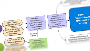
    Repeated extreme events have increased public awareness of the impacts of climate change, driving policies and practices across the Southeast region. These efforts require new and innovative partnerships and sound science to inform adaptation actions on the ground.

    Image
    High Plains Regional Climate Center Climate Summaries

    Pagination

    • First page « First
    • Previous page ‹ Previous
    • …
    • Page 35
    • Page 36
    • Page 37
    • Page 38
    • Current page 39
    • Page 40
    • Page 41
    • Page 42
    • Page 43
    • …
    • Next page Next ›
    • Last page Last »
    Subscribe to

    Climate.gov
    • News & Features
    • Teaching Climate
    • Maps & Data
    • FAQs
    Main Menu
    • About
    • FAQ
    • Contact
    • Acknowledgments
    • Sitemap
    Latest
    • Funding Opportunities
    • Glossary
    • Announcements
    Partners
    • climate.data.gov
    • climate.gov
    • USA.gov
    • NEMAC
    Toolkit
    • Case Studies
    • Tools
    • Funding
    • Steps to Resilience
    • Popular Resources

    Climate Resilience Toolkit home link

    Required Footer Links
    • NOAA Privacy
    • Accessibility
    • FOIA
    • Information Quality
    • No-FEAR Act
    • Ready.gov
    • USA.gov