Stressors and impacts
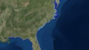
Residents of coastal Mississippi are no strangers to coastal flooding. In addition to flooding that occurs when hurricanes or tropical storms make landfall in the region, flooding can occur from inland events or seemingly minor storms, because the nearly flat coastal topography doesn't move water off the land very quickly. Though rising sea level also threatens this region, most residents don't have a good idea of how their community would fare with an additional foot or two of water.
Community engagement at the mall
To help community members learn about the potential impacts of sea level rise, Mississippi's Coastal Hazards Outreach Strategy Team and Mississippi-Alabama Sea Grant set up an exhibit with at the Edgewater Mall in Biloxi. They displayed the Sea Level Rise Viewer on a large computer monitor, and invited shoppers to view maps of their region with different amounts of sea level rise. Using the Web-based tool, exhibit staff showed local residents the potential for flooding in their neighborhoods and other places they knew. Individuals also zoomed in to regional landmarks to see simulations of flooding for various amounts of sea level rise.
The ability to see the potential impacts from sea level rise proved to be a powerful tool for those who attended the exhibit. In addition to the community members who stopped by, 12 local coastal and floodplain managers attended the event, saw the visualizations, and discussed issues associated with sea level rise. Several of the floodplain managers who attended were previously unaware of the visualization tool and were eager to learn more about it to use it in their own work.
One step toward building resilience
Outreach events like this can be a first step toward building resilience. The event increased awareness among members of the public and also gave coastal and floodplain managers an opportunity to engage directly with people whose lives and livelihoods are at risk from sea level rise. This simple model of gathering regional experts in a venue where they participate in public outreach can increase the number of residents who are aware of and willing to engage in building climate resilience.